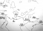
Williamson County area as it existed in 1720, prepared by Ron Emery
Map drawn up from Nannie Gray’s 1939 map by Ron Emery, isolating which areas of the county early French trappers and Shawnee indians inhabited and lived. The French had established a fort at Kaskaskia, south of St. Louis in 1703.
Their was an established trail that ran from Fort Kaskaskia to Fort Massac (Metropolis) called the Grand Trace that was used by the French for egress through this end of the state. This trail was used by George Rogers Clark in 1778 with his Kentucky volunteers when he fought the western portion of the Revolutionary War. Entering at Massac, his troops used the Grand Trace to get to Fort Kaskaskia. They took the British occupying troops off guard and took the fort without firing a shot. They would later, through a brutal winter, march back across Southern Illinois to take the British held fort at Vincennes Indiana. Ironically, George Rogers Clark would later die honorless and indebted, even though he had used his own money to finance the campaign.
The Grand Trace enters our county at Pulley’s Mill in the southern side and passes through Bainbridge on the west side of Marion where you turn off of old Route 13 to get the Heartland Regional Hospital. The trace exits our county just on the north side of Blairsville.