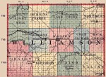
1875 Williamson County Map
This is an 1875 map of Williamson County. It illustrates some of the changes that has occured to township precincts as the population has sorted itself out over time.
In this map there are 12 townships as there are today but they are slightly skewed from today and some are named differently. Eight Mile, named after the prairie, is now Blairsville. Herrin Prairie, named after the prairie, is now Herrin. Northern is now Corinth. What is now Carterville township (Township 9, Range 1) was then a combination of Eight Mile and Grassy. What is now Crab Orchard was then a combination of Crab Orchard and Rock Creek. What is now Southern was then Union. What is now Stone Fort township was then Saline.
This is beneficial information for those doing genealogy to determine where a person lived in that time, because census information usually contains the precinct or township they were occupying at the time.