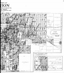
1918 East Marion Map
This is a map of East Marion which extends from two blocks west of the Square to the eastern edge of the city limits in 1918. Note that, even then, there appears to be a store location on E. Main Street where Small’s grocery is located today. The Griggs Brick plant is located at the end of East College Street. There were four or five ponds in the current location of the city resevoir marked Water Works and Electric. The location of the old High School is still marked as on E. Main St. even tho the new high school was in use at this time on W. Main Street.
This is a very large file and is about 2.4 Megabytes and 52″ x 59″. To be able to see the detail, I have left it in its large state. To make it visible just keep clicking on the image till it reaches full size. You may have use the zoom function on a graphic viewer to observe detail depending on your system.
(Map from Land Records at Ancestry.com)