
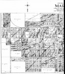
1918 West Marion Map
This is a map of West Marion which extends from one block west of the Square to the western edge of the city limits in 1918. There are lots of interesting details to observe in this map. Note the curve of the Coal Belt Electric Railway tracks at the end of North Carbon (top left of map). The curve of the tracks is still visible today in the treeline that surrounds the west end of the soccer fields behind the Catholic church today. Also visible, is the mill pond at the four way intersection of Rt 13 and Rt 37. Note that the creek has been slightly rerouted over time and now passes under the intersection instead of around it to feed the mill pond.
This is a very large file and is about 2.2 Megabytes and 52″ x 59″. To be able to see the detail, I have left it in its large state. To make it visible just keep clicking on the image till it reaches full size. You may have use the zoom function on a graphic viewer to observe detail depending on your system.
(Map from Land Records at Ancestry.com)