 To the best of my knowledge, the Bainbridge addition was incorporated into the city of Marion in the post-World War II era of the 1940’s by Lawrence Bainbridge, grandson of J.B. Bainbridge, at roughly the same time period as the Midway Court area and after Elmwood Place which consists of First, Second, Third and Fourth Streets. The area is comprised of Bainbridge Road, Charlotte Road and Sherry Road.The streets of Charlotte and Sherry Road were named after his grandchildren Charlotte (Bainbridge) Cash, the daughter of Bill Bainbridge, his son and Sherry (Hudgens) Austin, the daughter of Winifred (Bainbridge) Hudgens, his daughter.
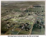
The area known as Bainbridge Square was comprised of an area bounded on the east by S. Carbon and on the west by the V.A. Hospital grounds at the end of Copeland Street. It is bounded on the north by W. Copeland and the south by Bainbridge Road.
This aerial photo taken in May of 1952 by local studio photographer Carl Sorgen captures a moment in Marion history when many of the streets remained unpaved and many residences inside the city limits were actually still farmland.
Note that Crab Orchard Lake and many of the Ordill area bunkers are visible in the top, left of the frame. Interstate 57 won’t arrive for another 12 years.
A larger version of this photo is available upon request.
(Photo by Carl Sorgen Studios and courtesy of the Williamson County Historical Society)