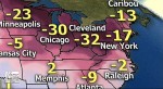
 A rare weather condition described by the National Weather Service as a “polar vortex” or a large swirling mass of arctic air dropped into the United States causing record low temperatures in early January 2014 across the country.
Southern Illinois, depending on where you lived, received anywhere from very little to several inches of snow followed by subzero temperatures that was part of “one of the coldest air masses in years” to blanket the region, according to the National Weather Service.
The leading edge of the vortex reached Marion on Sunday, January the 5th and produced mostly rain that eventually turned to blowing snow leaving a deposit of about two to three inches of snow. The evening brought more intense winds accompanied by a quick drop in temperatures to about 4 below, reflecting a wind factor of around minus twenty degrees or lower.
On Monday, January 6th, temperatures hovered around the zero mark and with accompanying wind drove the effective temperature into minus figures. Numerous reports of burst pipes and one report of an area death were attributed to the cold.
Most schools, public offices and many businesses were closed on Monday the 6th due to wind chill temperatures in the negative 20’s and ice covering the highways.
By Tuesday, the 7th, the vortex gradually moved off of the area, but most area schools and some public offices were still closed.
On Wednesday, more normal winter temperatures were experienced as the vortex cleared the area.
(Compiled by Sam Lattuca on 01/10/2014)