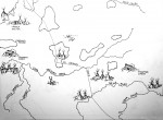
Map drawn up from Nannie Gray’s 1939 map by Ron Emery, isolating which areas of the county early French trappers and Shawnee indians inhabited and lived. The French had established a fort at Kaskaskia, south of St. Louis in 1703. Continue reading
Category Archives: All Marion Content
Samuel Knox Casey was born to Jesse M. and Cynthia Casey on a farm four miles north of Marion on March 6, 1865. Continue reading
The first official Marion City Hall appears to have manifested with the building of the Marion State and Savings Bank building being erected in 1903. Continue reading
This map captures current active towns and villages, railroads and creeks that existed in 1905. It was published in the 1905 Souvenir Book. Note that there were 14 precincts then instead of 12. Western, Northern, Saline and Rock Creek precincts no longer exist and Union is now Southern.