 At the close of the Revolutionary War, a great many soldiers were discharged and sent home without their pay. To remedy this, the Continental Congress passed an act granting to every such discharged soldier one hundred acres of land, to be selected by him within a prescribed territory; and on October 22nd, 1787, that congress set off as a reservation for that purpose, a portion of land in the Northwest Territory, described and bounded as follows: Continue reading
Category Archives: Maps
 Charles W. Hay was a prominent businessman and merchant for decades in Marion. He was an active member of the Marion Retail Merchants, the Marion Chamber of Commerce and numerous other civic organizations promoting the business atmosphere of Marion and “Little Egypt”. Continue reading
 From well before the turn of the century, coal became king in Southern Illinois and reshaped the economies and landscape of many counties, Williamson County among them. Coal mining has always been part and parcel of the lives and livelihoods of most of the citizenry of this county and back in the day if you didn’t work for the coal mines you assuredly knew someone who did. Continue reading


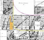
Lilly Curve
Mrs. Ollie Anderson, 1613 West Main Street can look back at what has transpired during the last 79 years from the perspective of the oldest resident of the street where she came to live in 1898. With the exception of one five-year period in another location she has lived on West Main Street since she came to Marion with her parents at the age of five. Continue reading