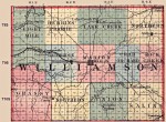
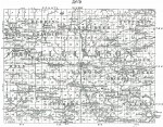
1876 Williamson County Map
This is a map of Williamson County in 1876. Note that Eight Mile township in 1875 used to occupy Township Township 8, Range 1 but has now dropped into the Township 9, Range 1 slot occupied today by Carterville township. In its place, on this map, is the Western Township sitting in the Township 8, Range 1 slot. The other townships appear to have remained in their respective positions as in 1875.