

On Friday, October 28th, 1960, the Marion Public Square was bypassed by new Illinois Route 13. For the first time, east and west bound traffic on Route 13 no longer had to pass through the middle of town and around the square with the completion of DeYoung from N. Fair Street on the east side of Marion.
Traffic at this time still had to enter and exit Marion from the east on old 13, but got jogged by way of N. Fair which had to have three blocks from Boulevard to DeYoung converted from the old tar and chip city street to a paved surface as is explained in the following article. Continue reading
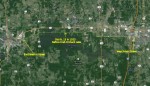 The road leading to Carbondale from Marion that we now know as new Route 13 is a far cry from what or where it was in the early days when it was no more than a trail. Before Crab Orchard Lake was constructed around 1939, and a section of Route 13 was re-located around it, there was old Route 13, a narrow road extending out West Main Street in Marion and running almost straight, dead west to Carbondale, joining East Walnut in Carbondale, about a half mile south of where new Route 13 now intersects Giant City Road. Continue reading